

From navigating the backcountry to scouting to identifying public and private land boundaries to finding the top trophy counties in your state, this app turns your phone into the ultimate hunting resource.
by the HuntDaily staff; promoted by onXmaps
Hunters seem to have a love-hate, on-again off-again relationship with certain technologies in the field. Many products give us googly eyes when they first come out but end up in the spare gear box one or two seasons later. GPS units are great examples. Most of us have used them at some point, and for serious backcountry hunting, GPS technology is as essential to us as a good pair of boots. But with mobile devices filling in much of the functionality of old-school GPS devices, many of our friends have relegated their GPS units to the dusty gear bin.
The problem is that basic cell phone functionality is limited for our hunting purposes. Sure, you can get your coordinates and mark your location, but lacking a good data signal, it’s not a lot of help if you can’t acquire mapping or satellite imagery.
Well, that was yesterday. Today, there’s a whole new way to “know where you stand” when you’re in the field. What’s more, this new technology delivers critical data for the hunter that is found nowhere else. It works from your iOS or Android mobile device, whether you have a data signal or not, so no matter if you’re hunting your backyard or the Back Forty, you’re always in the game. We’re talking about the onX Hunt App from onXmaps. We’ve been test-driving it for a while now, and for hunters who sprint across ridges and valleys after spring gobblers or who chase elk across the high mountains, this app may be the best investment you’ll ever make for your navigation needs.
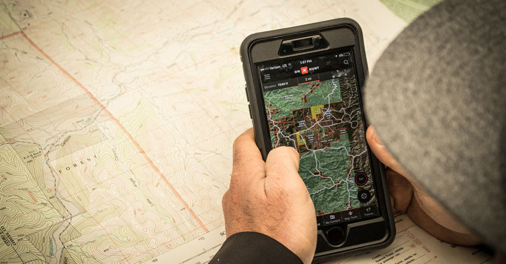
The onX Hunt App is a simple download to your mobile device via iTunes or GooglePlay. Once you set up an account, the app is also mirrored on your desktop or tablet, effectively linking the data you input on your phone to your computer and vice versa.
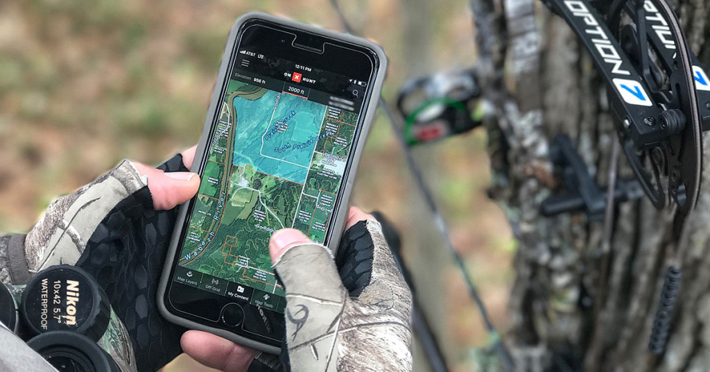
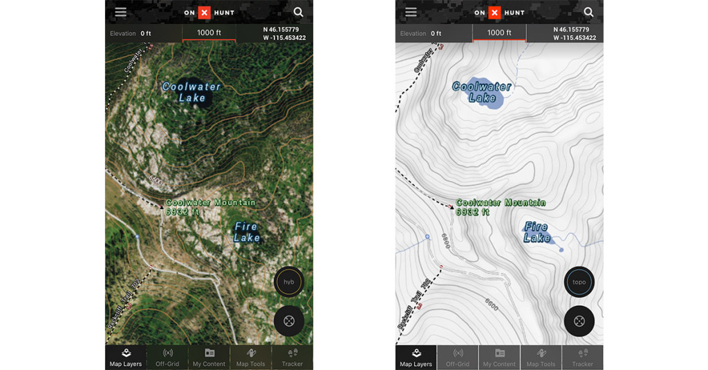
The free base maps for the onX Hunt App includes hi-res satellite imagery covering the U.S., a topographical map, and a hybrid map that combines satellite imagery and topo contour lines. The latter makes it easier to identify draws, ridgelines, and other key geographic features hunters find useful versus either an image or topo map used separately. A simple tap on the screen icon lets you toggle between the three map displays.
Other features in the free app include tools for establishing waypoints, straight-line distances between two user-selected points, user-defined area acreage, a tracking function, search, and offline maps.
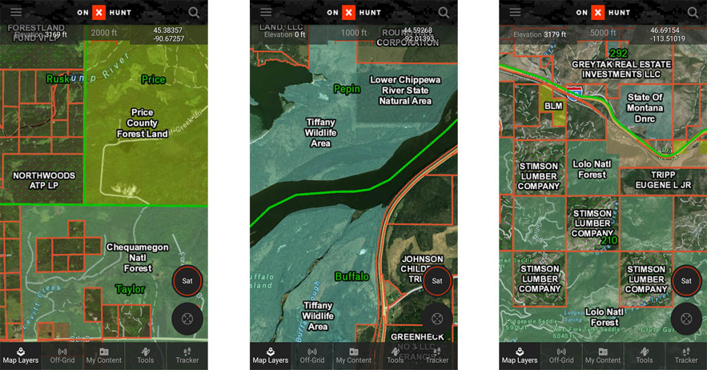
While this is good stuff to have on the phone you’re already carrying in the field, the feature that stands out most to us is the “State” layers found in the Premium and Elite onX Hunt App membership.
When you set up your onX account, you can subscribe to either the Premium or Elite membership service. Both give you Advanced Map Layers—one-state coverage with the Premium membership or 50-state coverage with the Elite. There are several state layers you can overlay onto the base map (which vary from state to state), but the most important to hunters are the private and public land segmentation. This function is the core benefit of the onX Hunt App and is what spurred development of the app to begin with.
“We could never figure out where we were hunting,” explained Matt Seidel, onX product owner. “This was especially true in Montana, where property boundaries are not required. A lot of people missed out on hunting opportunities…even shot opportunities…because they didn’t know where the private and public boundaries were located.”
Figuring there had to be a better way, the onX mission and objectives were defined: establish and maintain current ownership data and survey boundaries for all private and public lands in the U.S. and apply these as an interactive layer to quality satellite imaging and topographical data. The result was a mapping and navigational system that lets the hunter in the field know exactly where property boundaries are located, and where the hunter stands in relation to these boundaries. For hunters across the country who wend and weave their way along intermittent public and private land holdings, this is big stuff.
But there’s more to it than that. Not only are private and public land boundaries delineated on-screen by property lines, the deed-holder of each property is also displayed. And it gets even deeper. Tap the landowner name on the screen and the onX Hunt App brings up contact information for the property based on tax records, along with the associated acreage. The implications for the hunter are obvious. Want to seek permission to hunt or trespass a parcel of private land? Now you know who to contact to do so.

In addition to property boundaries, the state layers also provide layers covering “possible access” property and state hunting units.
Another layer set available with Premium or Elite membership is the Nationwide Layers. These are sub-divided by Hunt, Trails & Recreation, and Water categories, each with data layers of use to hunters and backcountry travelers, such as Precipitation Radar, Roadless Areas, Timber Cuts, Trails, Trail Mileage, US Forest Service Motor Vehicle Roads, and more.
As a company, onX takes a participatory, pro-active stance in their support of public land access and wildlife conservation efforts. This has led to collaborations with some of the top hunting associations in the country, resulting in some unique data layers you’ll find nowhere else. The National Wild Turkey Federation layer, for example, delivers county-by-county turkey harvest data from NWTF records dating back to 1982. Within the NWTF layer, you can choose additional layers that give granular data on turkey records for a particular county. These include overall bird score, five-year average, weight, beard length, spur length, and sub-species distribution. Other conservation association layers come in partnership with the Rocky Mountain Elk Foundation and Boone & Crockett. For the Western hunter, there’s even an Eastmans’ layer that provides all the harvest and draw highlights for specific hunt units on the map.
Because data signals can be spotty to non-existent when hunting, the onX Hunt App allows you to save all three base maps and the current layers turned so you can have all the critical functionality even when you can’t connect. There are three different resolution settings you can choose from that cover everything from an entire state (low-res), to 100 square miles (medium-res), and 25 square miles (high-res). Using the off-line function with your phone turned to airplane mode will deliver the navigation data you need without burning through your battery.
We mentioned earlier that the onX Hunt App works with both your mobile device and desktop computer. Both sync automatically so that whenever you add data to your mobile device, such as waypoints and tracking, it will also show up on your desktop app whenever you log in. The reverse is also true, and this is what makes the onX Hunt App a breeze for scouting and pre-trip planning. From the convenience of your desktop you can load points of interest (think funnels, draws, food sources, access points, et cetera) to your map and when you launch the app from your phone while in the field, there they are.
It’s almost too easy.
One of the problems we’ve had with conventional GPS systems of old that utilize downloadable maps and satellite imagery is the hassle of getting everything loaded and working together. Not so with the onX Hunt App. Once you set up your account, the presets give you everything you need to start hunting right away and to know where you are from the outset. The user interface and menu systems are equally simple and intuitive, so the learning curve is extremely shallow—even for those who aren’t quite comfortable with apps and digital interfacing.

We could talk a lot more about the available options and multiple uses this new technology brings to the hunting community, but the best way to discover what the onX Hunt App can do for you is to try it for yourself. Just go to iTunes or GooglePlay, download the app, and take advantage of the free seven-day trial period. The same log-in info works for your mobile device and desktop. After that, explore the possibilities. You may find that the ability to turn your phone into something worth more texting and taking photos in the field will hook you like it did us!
SOURCE
copyright © 2018 HuntDaily.com; promoted by onXmaps
Although onXmaps is one of our sponsors, the views expressed in this article are those of the author. HuntDaily.com receives compensation from onXmaps in various forms to help promote their products.
Leave a Reply